
The Maritime History of the Strait of Hormuz
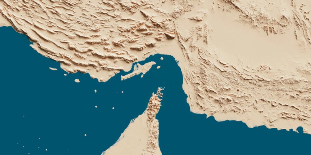
Few stretches of water carry as much strategic weight as the Strait of Hormuz. Running between Iran and Oman, the Strait represents one of the most important – and vulnerable – shipping routes in the world. In this article, we’ll explore the history of this unique stretch of water…
Setting the scene
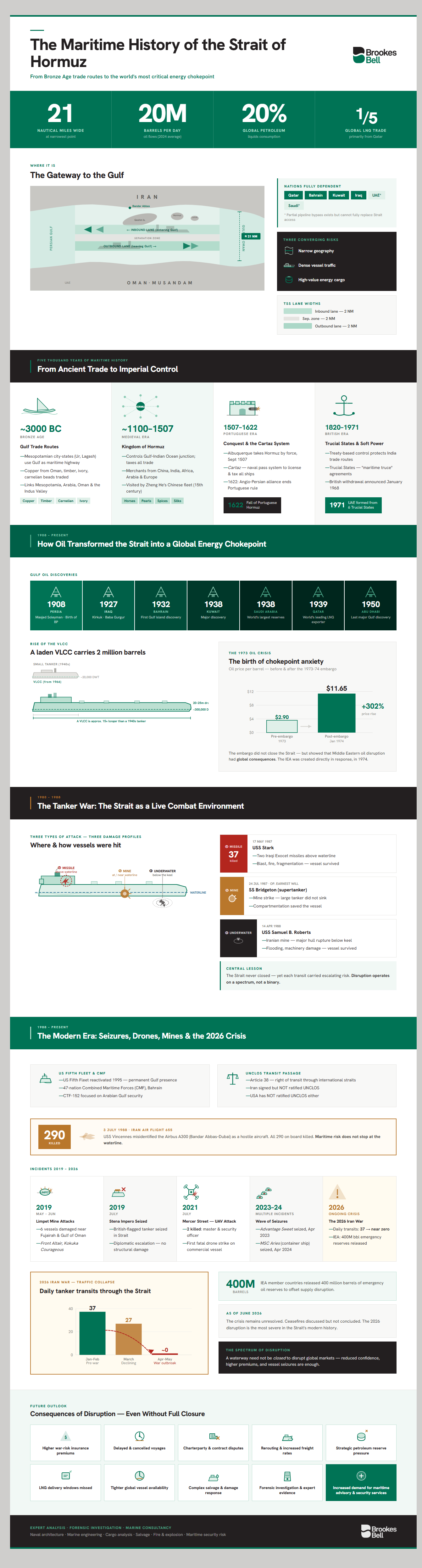
The Strait of Hormuz connects the Persian Gulf with the Gulf of Oman and the wider Indian Ocean. At its narrowest point, it is only around 21 nautical miles wide, yet it sits at the centre of global energy transportation, commercial shipping, naval strategy, and maritime security.
According to the U.S. Energy Information Administration (EIA), oil flows through the Strait averaged around 20 million barrels per day in 2024 – equivalent to about 20% of global petroleum liquids consumption – whilst around one-fifth of global LNG trade also transited the waterway, primarily from Qatar.
But, the importance of the Strait of Hormuz did not begin with oil.
For thousands of years, this narrow sea passage has been a strategically important link between the Persian Gulf with the wider trading systems of the Indian Ocean. Long before the emergence of modern tankers, naval patrols, traffic separation schemes, and war-risk premiums, the waters around Hormuz formed part of a maritime corridor used by merchants, empires, and regional trading powers.
Bronze age trade, the medieval Kingdom of Hormuz, Portuguese fortifications, British imperial influence and the rise of Gulf oil all helped shape the Strait into the critical chokepoint it is today.
Its modern significance, however, cannot be understood through history or geopolitics alone. The Strait of Hormuz is also a technical marine environment. Large tankers must transit constrained shipping lanes. Cargoes such as crude oil, naphtha, methanol, and LNG present very different risks when vessels are damaged.
Mines, missiles, drones, collisions, fires, seizures, and salvage operations all raise questions that require detailed vessel-level analysis.
So, in this article, we’ll explore the maritime history of the Strait of Hormuz from ancient trade to the modern oil era.
What is the Strait of Hormuz?
Yes, this may seem like a question with an obvious answer – but, what exactly does that name mean that you keep hearing in the media?
Put simply, the Strait of Hormuz is a narrow, but strategically vital sea passage between Iran and Oman. In stark terms – it is the maritime gateway between the oil- and gas-producing states of the Gulf and the wider global shipping network.
To the north lies Iran, including the important port city of Bandar Abbas and islands such as Qeshm, Hormuz, Larak, and Hengam. To the south lies Oman’s Musandam peninsula, a rugged exclave that projects into the Strait from the Arabian Peninsula.
This geography creates a natural constriction between the Persian Gulf and the open ocean, making the Strait one of the most closely watched waterways in the world.
Where is the Strait of Hormuz located?
The Strait of Hormuz sits at the mouth of the Persian Gulf. Vessels travelling eastwards out of the Gulf pass through the Strait into the Gulf of Oman before entering the Arabian Sea and the wider Indian Ocean. Vessels travelling westwards use the same route in reverse to enter the Gulf.
Its northern shore is controlled by Iran. Its southern side is formed largely by Oman’s Musandam Peninsula, with the United Arab Emirates (UAE) located nearby on the Arabian Peninsula.
It’s this position that gives the Strait of Hormuz its strategic importance.
It is not simply a route between two bodies of water; it’s the principal maritime exit from the Persian Gulf. For major Gulf energy exporters, the Strait is therefore the connection between regional production and global markets.
Why the Strait of Hormuz’s geography matters
As anyone who has ever read Prisoners of Geography or The Power of Geography will tell you, place matters.
The Strait is blessed (depending on your viewpoint) as it combines three things: narrow geography, dense vessel traffic, and high-value cargo.
Its narrow geography is especially important. At only 21 nautical miles wide at its narrowest point, the Strait of Hormuz represents a highly constrained environment for large vessels such as crude oil tankers, LNG carriers, container ships, naval vessels and other commercial traffic.
Several nations also rely on the Strait as their only means of accessing seaborne trade. Qatar, Bahrain, Kuwait, and Iraq all heavily depend on it for access to the open ocean. Whilst the UAE and Saudi Arabia do have some pipeline infrastructure that can bypass Hormuz, this doesn’t entirely negate the need for access to Hormuz.
It’s for these reasons that even a partial disruption can have significant consequences well beyond the Gulf. The issue is not only whether vessels can physically pass through the Strait. It’s whether they can do so safely, predictably, and in an insurable fashion. If a threat of mines, missile attack, drone activity, vessel seizure, or collision risk causes owners, charterers, or insurers to reassess transits, the commercial effect can be significant even without a complete closure.
A note on the Strait of Hormuz’s shipping lanes
Despite its strategic sensitivity, the Strait is not a simple unstructured passage. Instead, commercially traffic generally follows what’s known as a Traffic Separation Scheme (TSS). This is a managed routing system designed to reduce collision risk by separating vessels travelling in opposite directions.
Put simply, one lane is used by inbound vessels entering the Persian Gulf, whilst another lane is used by outbound vessels leaving it. The two lanes are separated by a buffer zone.
This arrangement is important as large commercial vessels do not manoeuver like small craft. For example, a laden tanker may require substantial sea room to alter course, slow down or respond to a developing hazard.
When vessels are moving through narrow lanes, the margin for error is significantly reduced. That is particularly important where traffic density is high, visibility is poor, electronic navigation is degraded, or security risks force vessels to change speed, route, or behaviour.
The TSS therefore helps impose order on one of the world’s busiest and most sensitive maritime corridors. But, it does not remove risk. It concentrates large vessels into predictable lanes, which can reduce ordinary collision risk, but may also create operational vulnerability during periods of geopolitical tension.
A note on depth, draught, and vessel transit
One of the common misconceptions about the Strait of Hormuz is that its narrowness makes it physically unsuitable for very large tankers. In reality, the main navigational issue is not whether the Strait is deep enough. It is how large vessels move safely through a constrained, high-traffic and politically sensitive waterway.
Water depth refers to the vertical distance between the sea surface and the seabed. Draught refers to the depth of the vessel below the waterline – in other words, how much of the ship sits beneath the surface when loaded. Grounding risk arises when a vessel’s draught approaches or exceeds the available water depth, allowing the hull to touch the seabed.
For very large crude carriers (VLCCs), draught can be around 20-25 metres when fully laden. However, the principal shipping areas of the Strait are much deeper than this. As the Strauss Center notes, the Strait is both deep and relatively free of maritime hazards, with the greatest depths near the Musandam Peninsula.
From a technical maritime perspective, then, the Strait of Hormuz is best understood as a complex operational environment rather than a shallow-water bottleneck. Its risks are shaped by the interaction between vessel size, traffic density, cargo type, navigation systems, available sea room, security threats, and the consequences of any casualty.
This is why incidents in or around the Strait so often require expertise in naval architecture, marine engineering, cargo behaviour, salvage, fire and explosion analysis, and forensic casualty investigation.
The Strait of Hormuz before oil: an ancient maritime trade route
At this point, we’re casting our gaze backwards. Very far backwards…
Long before oil tankers, LNG carriers, and naval patrols, the waters around the Strait of Hormuz formed part of one of the ancient world’s most important maritime corridors.
For thousands of years, the same geography that makes the Strait important today also made it valuable to ancient merchants: it controlled access between the Persian Gulf and the wider Indian Ocean.
In the Bronze Age, this meant that the Persian Gulf was not a remote or isolated body of water. Instead, it was a maritime highway linking southern Mesopotamia with the trading worlds of eastern Arabia, Oman, and the Indus Valley.
Bronze Age trade across the Persian Gulf
By the third millennium BC, merchants were using the Persian Gulf to connect some of the most developed urban societies of the ancient world. Southern Mesopotamian city-states such as Ur and Lagash needed access to raw materials that were scarce in the alluvial plains of Iraq. Timber, stone, metals and luxury goods all had to be imported from elsewhere.
The Gulf offered a maritime solution to this quandary.
Early commodities and maritime exchange
The goods moving through these early maritime networks were varied. Some were practical raw materials; others were prestige goods that signaled wealth, power, and access to distant trading partners.
Copper was one of the most important commodities. Mesopotamia lacked major local copper sources, whilst Oman and the wider Magan region were known for copper production. This made the Gulf a crucial route for the movement of metal into Mesopotamian cities.
Timber was another important cargo during this period. Southern Mesopotamia’s marshes and river plains did not provide the kinds of high-quality timber needed for construction, shipbuilding and elite projects.
Prestige goods were also transported through the Gulf. These included carnelian beads, shell objects, ivory, precious stones and other high-value materials. Of these materials, shell was particularly significant as it points directly to maritime exchange.
Taken together, we can see that these various commodities show that the Gulf was not simply a local waterway. It was a commercial corridor. Goods from Mesopotamia, Arabia, Oman, Iran, and the Indus region moved across a maritime network that depended on coastal sailing, island waypoints, harbour settlements, and knowledge of winds, currents and seasonal conditions.
The Kingdom of Hormuz and the rise of a maritime trading power
Fast-forward to the medieval period, and we can see that the waters around the Strait of Hormuz were no longer simply part of a wider trading route. Rather, they had become the foundation of a powerful maritime kingdom.
The Kingdom of Hormuz blossomed from a strategically placed port on the Persian mainland to develop into one of the great commercial centres of the western Indian Ocean.
Its strength came not from large agricultural hinterlands or abundant local natural resources. No, maritime geography was the source of its strength. Hormuz sat at the point where Gulf trade, Indian Ocean shipping, and overland caravan routes converged.
It was this position that allowed the kingdom to control, service, and tax the movement of goods between Persia, Arabia, India, East Africa and beyond.
The Kingdom of Hormuz is arguably the earliest example of a maritime trading power: a state with the ability to influence (and to a large extent, control) shipping, ports, customs revenue, and the security of commercial routes.
Hormuz as a medieval trading hub
As we’ve seen, Hormuz’s power came from its ability to connect worlds.
Ships came from the Gulf, India, Arabia, and the Red Sea. Merchants arrived from Persia, Gujarat, Malabar, Yemen, East Africa, Central Asia, and even further afield. The city did not simply handle local coastal trade; it functioned as a major Indian Ocean entrepôt, linking regional production with long-distance commercial networks.
Such a view is backed up by a 15th-century account by Abd al-Razzaq Samarqand – who described Hormuz as a major emporium frequented by merchants from Egypt, Syria, Anatolia, Persia, Turkestan, China, Java, Bengal, the Maldives, Malabar, Abyssinia, Zanzibar, Gujarat, Arabia, Aden, and Yemen. This extraordinary list shows the breadth of the city’s commercial connections.
Hormuz also appears in Chinese maritime sources. For example, Hormuz was among the major destinations of Zheng He’s later voyages in the 15th century. Chinese records also recognised Hormuz as an important node in trade with the Middle East and, indirectly, the Mediterranean.
Hormuz, then, was no mere port.
It was a meeting point between maritime and overland systems. Goods could arrive by ship, be stored or taxed on the island, then move onward to inland markets. Equally, goods from Persia and Central Asia could reach Hormuz by land before being exported by sea.
To put a modern twist on the situation, think of Hormuz as a transshipment and customs hub at the entrance to one of the world’s most important maritime corridors.
Horses, pearls, spices and luxury goods
The trade passing through Hormuz during the medieval period differed little from that which was traded in early ages.
It was highly varied.
Some cargoes were everyday necessities, including foodstuffs and the basic materials needed to sustain life on an island with limited local resources. But, Hormuz was especially associated with high-value goods: horses, pearls, spices, silks, previous stones, textiles, metals, dried fruits, and other luxury commodities.
The horse trade was particularly important.
Indian states, especially in regions where local conditions were less favourable for breeding strong cavalry horses, relied heavily on imported animals from Arabia, Persia, and central Asia.
Thus, Hormuz eventually became one of the principal maritime outlets for this trade in horses.
Pearls were another important part of Gulf commerce. The Persian Gulf was famous for its pearl fisheries, particularly around Bahrain. Pearls were portable, valuable, and well suited to long-distance trade.
Hormuz also sat within the spice and luxury goods trade that linked India, Arabia, East Africa and the Mediterranean.
These cargoes help explain the wealth and reputation of medieval Hormuz. It was not powerful because it produced all these goods itself. It was powerful because it sat at the point where they passed from one commercial world to another.
A target on its back
The wealth and position of Hormuz made it attractive. To control Hormuz was to control trade. To control trade was to control empires.
In a period when maritime trade was becoming increasingly important to substantiating imperial power, Hormuz represented both a commercial asset and a naval foothold.
It was an empire with a growing target on its back.
This is why the city eventually became a target for the Portuguese.
When Portuguese power expanded into the Indian Ocean in the early 16th century, Hormuz was one of the strategic points they sought to control. The logic was clear – an empire that wished to dominate Indian Ocea trade could not ignore the gateway to the Persian Gulf.
Portuguese and British control in the Strait of Hormuz
It was inevitable that someone would eventually take aim and fire at the target on Hormuz’s back.
By the early modern period, the Strait of Hormuz had become too important to be left outside the ambitions of expanding maritime powers.
Whoever controlled Hormuz could influence customs revenue, shipping routes, merchant access, and naval movement through one of the most important maritime gateways in Asia.
This is why the Portuguese, and later the British, became so heavily involved in the region. Their presence in the Strait was not simply about territory. It was about maritime control.
The Portuguese conquest of Hormuz
The Portuguese arrived in the Indian Ocean at the end of the 15th century with a clear strategic objective: to control the main sea routes linking Europe, Africa, Arabia, India, and Southeast Asia.
Hormuz was central to that ambition because it guarded the entrance to the Persian Gulf.
Afonso de Albuquerque – a Portuguese general, admiral, statesman, and conquistador – arrived off Hormuz in September 1507. He first ventured to Jarun – the island associated with New Hormuz – at the end of September and, using Portuguese artillery, defeated the forces controlling the kingdom.
Under a treaty concluded on 10th October 1507, the people of Hormuz recognised the sovereignty of the Portuguese king, agreed to pay an annual tribute of 15,000 ashrafi, and contribute to the construction of a Portuguese fort.
This first conquest wasn’t a resounding success, however. Albuquerque faced local resistance as well as troubles amongst his own men. Thus, he returned in 1515 with a much stronger force, consolidating Portuguese control and establishing a fortified presence on the island.
The Portuguese occupation of Hormuz was strategically significant because it inserted a European naval power into an existing Asian maritime trading system.
The cartaz system and control of maritime trade
Portuguese control in the Indian Ocean didn’t rest solely on the unbridled application of force. It also used that long-time friend of the bureaucrat – paperwork.
One of the main tools of the Portuguese was the cartaz system. A cartaz was a naval pass or licence issued by Portuguese authorities. In practice, it was intended to regulate which ships could trade, where they could sail and under what conditions.
Vessels without a valid cartaz could be treated as hostile or illegal by Portuguese patrols.
The system was part of a wider attempt to impose Portuguese authority over Indian Ocean trade. In the context of Hormuz, this mattered because the Strait was a natural checkpoint. Ships moving between the Persian Gulf and the Indian Ocean could be monitored, licensed, taxed, or intercepted. This gave the Portuguese a way to convert naval dominance into commercial power.
The fall of Portuguese Hormuz
For more than a century, the Portuguese reigned over Hormuz. But, it was never an uncontested reign.
By the early 17th century, Safavid Persia under Shah Abbas I was seeking to reassert control over Gulf trade and reduce Portuguese influence. The English East India Company also had strong commercial motives to challenge the Portuguese. This created the conditions for an Anglo-Persian alliance against Hormuz.
And so, in 1622, Persian forces – supported by English naval power – captured Hormuz from the Portuguese. This was a major turning point in the maritime history of the Strait. The fall of Hormuz ended the Portuguese position at one of the key entrances to the Gulf and altered the balance of commercial power in the region. It also demonstrated that control of a strategic maritime checkpoint could depend on alliances between land powers and naval powers.
For the Portuguese, the loss was both military and commercial. For the Safavids, it restored influence over a critical gateway. For the English, it opened the way for stronger commercial privileges in Persia.
This episode of history also foreshadowed a pattern that would be repeated time and again in later centuries: the Strait of Hormuz was rarely important to only one power at a time.
British influence and the Trucial states
With the Portuguese vanquished, British power and influence began to grow in the region.
Britain’s Gulf position developed through a mixture of naval force, treaty-making, commercial interests, and imperial strategy. Its main concern was the security of maritime routes connected to India, which was the centrepiece of the British Empire in Asia.
Throughout the 19th century, Britain entered into a series of agreements with rulers along the southern Gulf coast. These agreements helped create what became known as the Trucial States – the sheikdoms that later formed the United Arab Emirates.
If you’re wondering what the term ‘trucial’ means, you are not alone. But, it has naval roots – meaning ‘maritime truce’. Thus, these trucial state agreements were designed to reduce conflict at sea and stabilise British maritime interests in the Gulf. They also gave Britain significant influence over external relations and maritime security.
This British influence did not amount to the same kind of direct fortified control that the Portuguese had exercised at Hormuz. It was instead a form of maritime ‘soft/medium power’: treaty-based, naval-backed, and closely tied to imperial communications and commercial routes.
This arrangement lasted until the late 1960s/early 1970s.
In January 1968, the British government announced that it intended to withdraw its forces from the Gulf by the end of 1971. A 1971 parliamentary debate recorded in Hansard described the Gulf as an area of “outstanding strategic importance” and confirmed the planned termination of treaties with Bahrain, Qatar, and the seven Trucial States by the end of that year.
The British withdrawal helped reshape the political map of the lower Gulf. On 2nd December 1971, six former Trucial States – Abu Dhabi, Dubai, Sharjah, Ajman, Umm Al Quwain, and Fujairah – formed the United Arab Emirates. Ras Al Khaimah joined the federation shortly afterwards in 1972.
For the Strait of Hormuz, the British period is important because it shows another phase in the long history of maritime control. The Portuguese had tried to dominate the gateway through fortification, naval power and licensing. The British relied more heavily on treaties, naval presence, and protectorate-style influence.
In both cases, the underlying logic was the same: control over the waters around the Gulf meant influence over trade, security, and regional power.
How oil transformed the Strait of Hormuz
For most of its history, the Strait of Hormuz mattered because it controlled access to trade.
After the discovery of oil in the Gulf region, it became something even more consequential: a gateway between some of the world’s largest hydrocarbon reserves and the global energy economy.
Note that this transition did not happen overnight. It began with early oil discoveries in Persia, Iraq, and the Arabian Peninsula – then accelerated after the Second World War as Gulf production expanded and tankers grew larger.
By the latter half of the 20th century, the Strait was no longer just an important maritime route. It had become one of the world’s most important energy chokepoints.
This change also had a broader consequence. Disruption in the Strait would no longer affect only regional trade. It could influence oil prices, energy security, freight markets, insurance premiums, naval strategy, and the commercial decisions of shipowners, charterers, and cargo interests the world over.
The discovery of Gulf oil
The discovery that triggered this major transition occurred on 26th May 1908.
Oil was struck at Masjed Soleyman after years of exploration backed by William Knox D’Arcy and Burmah Oil. BP describes this as the “dawn of discovery”, noting that drilling at Masjed-i-Suleiman led to the discovery that ultimately gave rise to the Anglo-Persian Oil company (later, BP).
Further, massive discoveries soon followed.
The Kirkuk field was discovered at Baba Gurgur in 1927 and brought into production in the 1930s. Bahrain soon announced its own discoveries in 1932. Kuwait, in 1938.
Saudi Arabia’s defining breakthrough came in the same year – 1938.
Qatar’s first well was drilled in 1939, whilst Abu Dhabi was late to the party, with the country’s first exploration well only being drilled in 1950 at Ra’s Sadr.
Together, these discoveries changed the economic and maritime geography of the Gulf. Whilst the region had long been commercially important because of trade, pearls, horses, textiles, and strategic location – oil added a product that was set to become the ‘master resource’ of the global economy. A commodity that today, we literally can’t do without.
The growth of oil exports through the Strait
As Gulf production increased, the Strait of Hormuz became the key maritime outlet for a growing share of the world’s oil.
The logic was simple. Much of the region’s oil was produced inside the Persian Gulf. To reach international markets by sea, tankers had to pass through the Strait of Hormuz, then continue into the Gulf of Oman, the Arabian Sea, and the wider Indian Ocean. This made the Strait the critical passage between Gulf oilfields and refineries, power stations, and industrial economies around the world.
As a result, bodies such as the U.S. Energy Information Administration describes the Strait of Hormuz as the world’s most important oil transit chokepoint.
This is what turned the Strait from an important regional route into a global energy chokepoint. The importance of the Strait now hinged upon its ability to provide uninterrupted movement of oil cargoes through a narrow and politically sensitive waterway.
For Gulf exporters, the Strait became the link between production and revenue. For importing countries, it became a link between energy demand and supply security. For shipowners and insurers, it became a place where geography, cargo value, geopolitical risk, and vessel vulnerability overlapped.
The rise of the larger tankers
The transition to the oil era also saw a transition in the ships that used the Strait.
During the Second World War and the immediate post-war period, tankers were much smaller than the largest vessels that would later dominate long-haul crude oil transport.
However, by the dawn of the 1960s, tanker design entered a new phase. Demand for long-distance crude transport, combined with economies of scale, encouraged the construction of much larger vessels. For example, in 1966, the Idemitsu Maru entered service as the first 200,000 ton-class tanker.
We had entered the age of the VLCC – the Very Large Crude Carrier.
VLCCs allowed operators to move very large quantities of crude oil in a single voyage. Later, even larger ULCCs (Ultra Large Crude Carriers) would push the scale further.
For the Strait of Hormuz, the rise of these larger tankers changed the operational significant of the waterway.
A VLCC is not simply a bigger version of a small tanker. Its size affects draught, manoeuvrability, stopping distance, turning circle, collision consequences, and emergency response. When a laden tanker is carrying up to two million barrels of crude oil, an incident is not only a navigational problem. It can become a pollution event, a fire and explosion risk, a salvage challenge, a cargo-loss issue, an insurance dispute, and a geopolitical flashpoint.
This is where technical maritime expertise becomes essential.
The Strait is deep enough in its main shipping lanes for very large tankers to transit. But, safe passage depends on more than depth. It depends on routing, traffic management, machinery reliability, bridge-team performance, navigational data, security conditions and the vessel’s ability to respond to a developing hazard.
The 1973 oil crisis and the birth of chokepoint anxiety
The strategic importance of the Strait of Hormuz became much clearer during the 1970s.
The 1973-74 oil crisis showed how vulnerable industrial economies had become to disruption in Middle East oil supply. The U.S. Office of the Historian explains that the oil embargo contributed to a sharp upward spiral in prices, with the price of oil first doubling and then quadrupling.
The Federal Reserve similarly notes that oil prices rose from $2.90 per barrel before the embargo to $11.65 per barrel in January 1974.
This crisis did not involve the closure of the Strait of Hormuz. But it did change how governments, energy companies, and maritime planners thought about oil supply. It demonstrated that disruption to Middle Eastern oil could have global consequences.
It also showed that energy security was inseparable from maritime security.
The creation of the International Energy Agency in 1974 reflected this new anxiety. The IEA states that it was created in response to the 1973-74 oil crisis, when the embargo exposed the vulnerability of industrialised countries to dependence on oil imports.
For the Strait of Hormuz, the lesson was clear.
A waterway that carried Gulf oil exports could not be treated as just another shipping route. It was now part of the strategic infrastructure of the global economy.
The Tanker War and the modernisation of maritime risk
The Tanker War marked a turning point in the modern maritime history of the Strait of Hormuz.
It showed that the Strait’s importance was no longer limited to geography, trade or oil flows. By the 1980s, the waterway had become a live operational environment in which merchant ships, naval vessels, oil cargoes, insurers, and commercial crews were exposed to the direct consequences of state conflict.
What was the Tanker War?
The Tanker War formed part of the wider Iran-Iraq War, which lasted from 1980 to 1988.
As the land war became prolonged and costly, both sides increasingly looked to the sea. Oil exports were central to each country’s ability to fund the conflict, so tankers and oil terminals became strategic targets.
The result was a sustained campaign against commercial shipping in and around the Persian Gulf.
For shipowners, charterers, insurers, and crews, the Tanker War changed the way maritime risk in the Gulf had to be understood. It was not simply a matter of avoiding bad weather, mechanical failure, or navigational error. Vessels could be attacked by missiles, struck by mines, harassed by small craft or caught in the escalation between regional and international powers.
This is one of the core reasons the Tanker War remains so relevant to the Strait of Hormuz today.
It demonstrated that commercial shipping could become entangled in geopolitical conflict even when vessels themselves are not belligerents.
Attacks on tankers and merchant vessels
The attacks took several forms.
Iraq relied heavily on air power. Helicopters and fixed wing aircraft, including Mirage F1 and MiG-23 fighters, were used to attack shipping with anti-ship missiles such as the Exocet. These attacks were designed to damage vessels, disrupt Iranian exports and raise the cost of trading with Iran.
Iran used a different mix of methods. These included fast-attack craft, naval gunfire, shore-based missiles and naval mines. Mine warfare was particularly significant because mines could be deployed covertly, left in place and continue to threaten vessels long after they had been laid.
For crews, this created a highly uncertain risk environment. A vessel could be targeted by an aircraft, damaged by a mine, threatened by small craft or caught in the response of naval forces attempting to protect shipping. The risks were not theoretical. They involved fire, flooding, hull rupture, propulsion loss, blast damage, injury, and death.
From a maritime-risk perspective, the Tanker War also showed that not all attacks have the same operational consequences. A missile strike above the waterline produces a different damage pattern from a mine detonation beneath or alongside the hull. A hit to accommodation spaces creates different risks from a hit to cargo tanks or machinery spaces. A vessel that remains afloat may still face serious problems involving stability, structural integrity, cargo containment, crew safety, and towage.
Key incidents: USS Stark, SS Bridgeton, and USS Samuel B. Roberts
Three Tank War incidents show just how varied this maritime damage can be. Below, we’ve highlighted three of the most high-profile cases from the war:
- USS Stark (missile strike): on 17th May 1987, the U.S. Navy frigate USS Stark was hit by two Iraqi Exocet missiles in the Persian Gulf. The attacked killed 37 sailors and wounded 21. The vessel survived, but the incident demonstrated the severe effects of missile damage, including blast, fire, fragmentation, and casualties.
- SS Bridgeton (mine strike on a tanker): on 24th July 1987, the reflagged Kuwaiti supertanker Bridgeton struck a mine during the first convoy of Operation Earnest Will. Despite the damage, the tanker did not sink and was able to continue its voyage. The incident showed both the vulnerability and resilience of large tankers, whose size and compartmentation can help them survive damage that might be more serious for smaller vessels.
- USS Samuel B. Roberts (underwater explosive damage): on 14th April 1988, USS Samuel B Roberts struck an Iranian mine, which tore a major hole in the ship’s hull and triggered a significant damage-control effort. The vessel survived, but the incident highlighted the risks of underwater explosions, including hull rupture, flooding, machinery damage, and loss of structural integrity.
Together, these incidents illustrate three different forms of maritime casualty risk. Each produced different evidence, required a different technical response, and showed why vessel damage must be assessed at the level of structure, systems, cargo, crew response, and operational context.
Why the Strait did not close
One of the most important lessons of the Tanker War is that severe disruption does not always mean total closure.
In public discussion, the Strait of Hormuz is often framed in binary terms: open or closed. In reality, maritime disruption usually exists on a spectrum. A waterway may remain physically navigable, whilst becoming commercially unattractive, operationally dangerous, or prohibitively expensive for some vessels.
The Tanker War showed that the global shipping system can adapt to risk – but not without cost. Tankers continued to move because the commercial incentive to transport oil remained strong. But, each transit carried a different risk profile from a normal commercial voyage.
The question was not simply, “can the vessel pass through?”. It was, “at what level of risk, with what protection, at what cost, and with what consequences if something goes wrong?”.
This is a useful distinction for any modern discussion of the Strait. A crisis does not need to close the Strait completely to affect global markets. Reduced confidence, increased premiums, security restrictions, rerouting, port delays or a small number of high-profile casualties can all have commercial consequences.
The technical lessons of the Tanker War
The Tanker War modernized the way maritime risk in the Strait of Hormuz had to be assessed.
It showed that vessel casualties in the Gulf are not only political or military events. They are also technical events. Every attack leaves a physical record: damaged plating, fractured welds, distorted frames, fire patterns, flooding paths, machinery failures, cargo-tank effects, navigation data, crew testimony, and repair evidence.
Forensic casualty investigation is therefore essential. Investigators must determine not only that a vessel was damaged, but how it was damaged. A missile strike, a mine detonation, a collision, and an onboard explosion produce very different evidence.
The location of the damage, the direction of force, the pattern of deformation, the presence of residues, the condition of surrounding structures and the sequence of flooding or fire can all help establish causation.
Hull damage is only one part of the picture.
A casualty may also involve propulsion loss, steering failure, power interruption, fire spread, cargo leakage, stability loss, or pollution risk. A tanker carrying crude oil presents a different set of hazards from a vessel carrying refined products, chemicals, or LNG. Damage to accommodation spaces creates different crew-safety issues from damage to cargo tanks, ballast tanks, or engine-room systems.
The Tanker War also underlined the importance of repairability and salvage. A vessel that survives an attack may still require emergency stabilisation, towage, temporary repairs, cargo transfer, class involvement, port entry, damage surveys, and eventual shipyard repair.
In a contested maritime environment, each of these steps becomes more complicated. Salvage teams may face security restrictions, mine threats, fire hazards, pollution risk, and uncertainty over whether further attacks may occur.
This is why the Tanker War remains central to the modern history of the Strait of Hormuz. It was not the first time the Strait had been strategically important, but it was one of the clearest demonstrations that the security of a maritime chokepoint depends on the physical realities of ships as much as the political decisions of states.
From the Tanker War to permanent maritime security presence
The end of the Tanker War did not remove the Strait of Hormuz from the centre of maritime-security planning. In fact, the events of the late 1980s helped establish the Gulf as an area of permanent strategic concern for regional states, commercial shipping interests and international naval forces.
By this point, the Strait was no longer viewed simply as a narrow passage for oil tankers. It was a congested operating environment where merchant ships, naval vessels, aircraft, coastal states, and commercial cargoes all interacted in close proximity. That made risk management more complex. Incidents could escalate quickly and mistakes could have consequences well beyond the vessels directly involved.
Iran Air Flight 655 and escalation risk
A particularly pertinent – and tragic – example of this risk of escalation came on 3rd July 1988, when the US Navy-guided missile cruiser USS Vincennes shot down Iran Air Flight 655 over the Strait of Hormuz, killing all 290 people on board.
The aircraft was an Airbus A300 operating a scheduled civilian flight from Bandar Abbas to Dubai – but it was misidentified as a hostile military aircraft.
The incident showed how dangerous decision-making can become in a congested maritime and airspace environment. The Vincennes was operating during a period of heightened tension, close to Iranian naval activity and inside an area where military and civilian movements overlapped. In that setting, radar tracks, communications, perceived hostile intent and time pressure all formed part of the decision-making environment.
For the Strait of Hormuz, the lesson was severe.
Maritime risk does not stop at the waterline.
A crisis in the Strait can involve surface vessels, aircraft, helicopters, missiles, shore-based systems, commercial crews, and civilian passengers. When military and civilian traffic share a compressed operating space, errors of identification or escalation can be catastrophic.
The US Fifth Fleet and Gulf security architecture
With the Tanker War highlighting the strategic importance of the Strait of Hormuz, the United States decided to move towards a more permanent naval presence in the region.
The US Fifth Fleet was reactivated in 1995 and became responsible for naval operations across a large area including the Persian Gulf, Red Sea, Gulf of Oman, and parts of the Indian Ocean.
This permanent presence reflected the importance of the Strait. The aim was not only to respond to conflict, but to maintain maritime-security architecture that could support freedom of navigation, reassure partners, deter hostile action, and protect commercial shipping in one of the world’s most important energy corridors.
For shipowners and insurers, this changed the context in which Gulf risk was assessed. The Strait remained exposed to geopolitical tension, but it also sat within a more formalised security framework involving naval patrols, surveillance, coalition activity and crisis-response planning.
Combined maritime security structures
The Gulf maritime security environment is not managed by one navy alone. Rather, it involves a range of regional and international partnerships.
The most important of these is the Combined Maritime Forces (CMF). CMF describes itself as a 47-nation naval partnership headquartered in Bahrain, operating across a vast maritime area to promote security, stability, and prosperity. Its task forces cover different missions and geographies, including maritime security, counter-piracy, Gulf security, Red Sea security and maritime training.
Within this framework, the most notable for the purposes of this article is Combined Task Force 152 – which is the task force that is focused on maritime security in the Arabian Gulf.
Ultimately, these coalition maritime-security structures are now an embedded part of the commercial environment of the Strait. They shape how risk is perceived, how incidents are managed, and how quickly shipping confidence can recover after an escalation in the region.
Transit passage and international law
Such is the importance of the Strait of Hormuz that it is not treated as an ordinary stretch of territorial sea.
Under the United Nations Convention on the Law of the Sea, or UNCLOS, ships and aircraft enjoy a right of “transit passage” through straits that are used for international navigation. Article 38 defines transit passage as ‘freedom of navigation and overflight for continuous transit through such straits’.
For non-lawyers, the key point is this: transit passage is designed to prevent coastal states from simply blocking international navigation through a strait that connects major bodies of water.
This is especially important in a waterway such as Hormuz, where commercial ships may need to pass through the territorial seas of coastal states in order to move between the Persian Gulf and the open ocean.
However, legal interpretations are politically sensitive.
Iran has signed, but not ratified UNCLOS, whilst the United States has not ratified it either. That means disputes can arise over how treaty law, customary international law and coastal-state security claims apply in practice.
This is why law, security, and shipping operations cannot be separated in the Strait of Hormuz. A vessel may have a legal right to transit, but commercial operators still have to consider the practical risks: naval warnings, insurance conditions, flag-state advice, charterparty obligations, crew safety, cargo value, and the possibility of escalation.
In a sense, then, the Tanker War and its aftermath made the Strait of Hormuz a passage where maritime law, naval presence, commercial shipping, and technical risk all have to be managed at the same time.
Modern vessel incidents and seizures in the Strait of Hormuz
The Strait of Hormuz may be dominating headlines at the time of writing (June 2026), but it is an area that has been persistently troubled in recent times by a spate of seizures, attacks and other provocations.
Since the late 2000s, the waterway and its approaches have seen a repeated pattern of tanker attacks, vessel seizures, drone strikes, navigational disruption, and security escalation.
These incidents perhaps show why the Strait must be understood as more than a geopolitical flashpoint. It is also a technical maritime environment, where vessel design, cargo type, hull damage, blast evidence, navigation systems, salvage response, and crew safety all matter.
Below, we’ve explored some of the more notable incidents that have occurred within the Strait over the past few years.
The 2019 limpet-mine attacks
In May and June 2019, a series of attacks on tankers near the Strait of Hormuz brought renewed attention to the vulnerability of commercial shipping in the region.
This incident began with four commercial vessels being damaged off Fujairah, near the eastern approaches to the Strait. A month later, on 13th June 2019, two more tankers – Front Altair and Kokuka Courageous – were damaged in the Gulf of Oman. The attacks took place outside the Strait itself, but close enough to affect confidence in one of the world’s most important energy corridors.
The US attributed the June attacks to limpet mines. Limpet mines are explosive devices that are designed to be attached to a vessel’s hull, often magnetically. Unlike a torpedo, which normally strikes below the waterline, a limpet mine may be placed above or near the waterline depending on the intended effect. In the Kokuka Courageous case, US Central Command said the crew had abandoned the vessel after discovering an unexploded limpet mine on the hull following an initial explosion.
The Stena Impero seizure
Later in 2019, the crisis escalated from attacks on vessels to the direct seizure of a merchant ship.
On 19th July, Iranian forces seized the British-flagged tanker Stena Impero in the Strait of Hormuz. The UK government stated that the vessel had been seized in Omani waters and described the incident as a contravention of international law.
The seizure took place shortly after the detention of the Iranian tanker Grace 1 off Gibraltar, creating a clear example of how commercial vessels can become entangled in state-to-state escalation. Stena Impero was not simply a ship in transit; it became a diplomatic pressure point.
For vessel operators, the lesson was stark. A ship does not need to suffer structural damage to become a major casualty or claims event. A seizure can create serious consequences for crew welfare, charterparty performance, cargo delivery, insurance, legal exposure, reputational risk, and operational planning.
The Stena Impero incident also highlighted the vulnerability of predictable shipping routes. Tankers using the Strait follow constrained lanes and are often visible through AIS, voyage reporting, and commercial tracking systems. In a tense security situation, this predictability can become a risk factor.
The Mercer Street drone attack
In July 2021, the attack on Mercer Street showed how unmanned systems had become part of the threat environment for commercial shipping.
Mercer Street was a Liberian-flagged, Japanese-owned tanker managed by Zodiac Maritime. It was attacked off Oman on 29-30th July 2021. Two members were killed: the Romanian master, and a British security officer.
US Central Command concluded that the vessel had been targeted by two unsuccessful explosive UAV attacks on 29th July, followed by a third UAV attack on 30th July. It was the third attack that caused the extensive damage and fatalities.
Vessel seizures in 2023 and 2024
Following the Mercer Street attack in 2021, vessel seizures began to ramp up in and around the Strait – significantly changing the risk picture of the region.
In April 2023, Iran seized the Marshall Islands-flagged tanker Advantage Sweet in the Gulf of Oman.
Other vessels were subsequently drawn into seizures or attempted seizures. For example, on 5th July 2023, US Naval Forces Central Command reported that US Forces had prevented two attempted commercial tanker seizures by the Iranian Navy in the Gulf of Oman. The incidents involved the TRF Moss and Richmond Voyager.
April 2024 saw Iran seizing the Portuguese-flagged container ship MSC Aries in the Strait of Hormuz. Iran claimed that the vessel had violated maritime laws, whilst MSC confirmed that the ship had been seized and said it was working with the authorities to secure the vessel’s safe return and the wellbeing of its 25 crew.
As these incidents show, it isn’t just tankers that face risk in the Strait of Hormuz. Container ships, product tankers, crude tankers, and other commercial vessels can all become exposed where ownership, chartering, cargo, flag, route, or perceived political links bring them into a wider dispute.
The 2026 Strait of Hormuz crisis
Arguably the largest crisis to afflict the Strait of Hormuz, the 2026 Iran War saw tanker traffic through the Strait fall to a near complete halt.
Daily tanker passages reportedly dropped from 37 to 27 throughout February to zero within only a few days of the outbreak of war.
The Strait’s importance as an energy corridor was emphasised by the IEA’s announcement soon after the start of the war that member countries would make 400 million barrels of emergency oil reserves available to the market.
At the time of writing (June 2026), the 2026 Strait of Hormuz crisis remains unresolved, despite various talks of ceasefires, deals and negotiations.
Why future disruption scenarios matter to global markets
And, thus we come to the end of our maritime history of the Strait of Hormuz. Like many strategically important geographic locations, it has long been the source of conflict, turmoil and conquest.
As the 2026 Iran War shows, this is a pattern that is unlikely to change in the future.
Looking forward, how do we expect the Strait to change? And, what role will it continue to play for the worlds of shipping and energy. Let’s explore…
For shipowners, charterers, insurers and energy buyers, the more pressing challenge is likely to be recurring disruption: short periods of heightened threat, selective vessel seizures, drone activity, mine warnings, electronic-navigation interference, naval restrictions or sudden changes in war-risk insurance.
Even if the Strait remains technically open, these conditions can still affect whether vessels are willing – or able – to transit.
This matters because global energy markets depend on confidence as much as capacity. Tankers need to move on predictable schedules. LNG cargoes need to reach buyers within agreed delivery windows. Refineries need reliable feedstock. Insurers need to price risk.
When uncertainty rises, the commercial effects can spread quickly through freight, insurance, chartering, and supply-chain planning.
Future disruption in the Strait could lead to:
- Higher war-risk insurance premiums.
- Delayed or cancelled voyages.
- Increased freight rates.
- Changes to charterparty terms.
- Greater use of alternative crude grades.
- Pressure on strategic petroleum reserves.
- LNG delivery uncertainty.
- Tighter vessel availability.
- More complex voyage planning.
- Increased demand for security, salvage, and technical advisory support.
The key point is that a waterway does not need to be permanently closed to create global consequences. A limited incident involving one tanker can affect market sentiment.
The technical maritime risks behind the headlines
Throughout this article, we’ve examined the major events and incidents that have shaped the Strait of Hormuz throughout history.
However, behind many of those events (especially the modern ones), are often technical maritime questions and risks.
The Strait of Hormuz is ultimately a technically complex operating environment for mariners. Below, we’ve highlighted the biggest risks and challenges to shipping navigating the Strait.
Navigational risk in a narrow high-traffic waterway
The Strait of Hormuz is not simply narrow; it’s narrow, busy, and commercially critical.
Large tankers, LNG carriers, container ships, naval vessels and support craft may all be operating in the same constrained area. Traffic Separation Schemes (TSS) are used to help organise this movement by separating opposing streams of traffic, a system recognised by the International Maritime Organization (IMO) as a way of improving navigational safety in busy or sensitive waters.
Even with structured traffic lanes, large vessels need significant sea room.
A VLCC or large LNG carrier cannot stop or turn quickly. Its stopping distance, turning circle and ability to take avoiding action depend on factors such as speed, draught, loading condition, under-keel clearance, wind, current, machinery response, and bridge-team decision-making.
This matters in the Strait because the room for error is limited. A developing close-quarters situation may involve:
- Restricted sea room.
- Dense commercial traffic.
- Vessels of very different sizes and manoeuvering characteristics.
- Naval or security-related activity.
- Degraded AIS or GNSS data.
- Uncertainty over the intentions of nearby craft.
- Limited time to assess and respond.
In normal conditions, good voyage planning, bridge resource management, pilotage procedures, lookout, radar, ECDIS and AIS all help reduce risk. In a security crisis, however, vessels may also be dealing with warnings, exclusions, escort instructions, spoofed positioning data, or pressure to maintain schedules.
Such pressures can make collision avoidance and passage planning materially more complex.
Salvage in contested waters
Salvage is difficult in any major casualty. In contested waters, it becomes increasingly more complex.
A damaged tanker may need firefighting, towage, stabilisation, temporary repairs, cargo transfer, pollution control, emergency power, class attendance and eventual movement to a port or repair yard.
Each of these tasks becomes harder if the casualty is in an area affected by mines, drone threats, missile risk, naval activity or political uncertainty.
Salvors may have to assess whether it is safe to approach the vessel at all.
They may also need to consider whether there are unexploded devices, continuing fire risk, toxic vapours, unstable cargo, damaged mooring or towing arrangements, or the possibility of fire risk.
Commercial issues also matter. In a war-risk environment, salvors may face exceptional operational costs and unusual danger to crews, tugs, and equipment.
This is why salvage response in or near the Strait of Hormuz is not only a technical problem. It is a coordinated maritime operation involving owners, insurers, salvors, coastal states, naval authorities, flag states, class societies, cargo interests and sometimes governments.
War-risk insurance and commercial exposure
The commercial consequences of a Strait of Hormuz incident can extend far beyond the damaged vessel.
War-risk insurance, hull and machinery cover, P&I exposure, cargo insurance, delay claims, salvage costs, wreck removal, pollution liabilities and charterparty disputes may all be affected.
In a high-risk area, owners and charterers may also need to consider whether a vessel can be ordered to proceed, whether the route remains safe, and who bears the cost of delay, deviation or additional premiums.
This commercial exposure is one reason the Strait of Hormuz can affect shipping markets even without complete closure. If insurers increase additional premiums, if charterers refuse certain routes, if owners require security assurances, or if cargo interests expect delay, the consequences can spread through freight rates, vessel availability, and supply-chain planning.
Brookes Bell: providing the technical insight you need for today’s maritime challenges
The history of the Strait of Hormuz shows why this narrow waterway remains so important to global shipping. Its significance is not only political or commercial; it is also technical.
Vessel movements, cargo behaviour, navigational risk, hull damage, salvage response, and evidence preservation all shape how incidents in the Strait are understood and resolved.
Brookes Bell supports maritime stakeholders with independent technical expertise across casualty investigation, naval architecture, marine engineering, cargo science, fire and explosion analysis, salvage, and expert witness services.
In complex environments such as the Strait of Hormuz, that expertise can help owners, insurers, legal teams and other parties understand what happened, assess the consequences and make informed decisions.
Contact Brookes Bell to discuss your requirements today
For more maritime industry news, insights and developments, read the Brookes Bell News and Knowledge Hub…
A History of the Panama Canal | A Brief History of the Suez Canal | The World’s Largest Shipbuilding Companies
- Date
- 22/07/2026